CSE:GDN  ·  GOLDEN AGE EXPLORATION LTD.  ·  TRADING ON THE CANADIAN SECURITIES EXCHANGE

Australian Uranium Projects

Uranium: Maps

Exploration maps for Golden Age Exploration's three Australian uranium projects. Each map is presented at full resolution with salient facts to orient the viewer on tenure, known mineralisation, and exploration targets.

Portfolio Overview
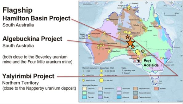
Portfolio overview map — Hamilton Basin (SA), Algebuckina (SA), and Yalyirimbi (NT) project locations relative to operating uranium mines

Project locations relative to operating uranium mines and known deposits — South Australia & Northern Territory

Portfolio at a Glance

Hamilton Basin

South Australia

ELA applications · ±9,000 sqkm target corridor

Roll-front / Palaeo-channel

Algebuckina

South Australia

1 EL granted · 273 sqkm

Unconformity / Roll-front

Yalyirimbi

Northern Territory

1 EL + 2 ELA · 324 sqkm

Palaeo-channel / REDOX

Flagship

South Australia · Flagship Project

Hamilton Basin

South Australia

One of the largest untested uranium targets globally — a roll-front / palaeo-channel corridor ±180km × 50km in strike length. The basin architecture closely mirrors the uranium-producing Frome Embayment to the east and the world-class Kazakhstan in-situ recovery (ISR) districts.
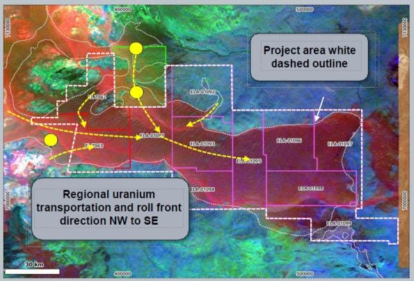
Regional Project Map

Hamilton Basin regional project map — uranium transportation vectors, roll-front direction NW to SE, ELA tenure blocks, South Australia

Regional project area showing uranium transportation vectors, roll-front direction NW → SE, and ELA tenure blocks across the Hamilton Basin corridor.

Key Facts

Target Size±180km × 50km strike corridor — one of the largest untested uranium targets globally
Known UraniumUp to 190ppm U (±300ppm V) in carbonaceous palaeo-channel sediments, Jurassic–Cretaceous age
Deposit StyleRoll-front / palaeo-channel hosted · REDOX-controlled uranium
Exploration ModelUranium transported NW → SE by oxidising groundwater; precipitated at REDOX boundary in carbonaceous sediments
Deposit AnaloguesInkia (Kazakhstan) · Four Mile · Beverley · Honeymoon · Mulga Rock
TargetsStacked roll-front, tabular palaeo-channel and incised palaeo-channel REDOX deposits
±180km × 50km TargetRoll-Front / Palaeo-ChannelGlobally Significant ScaleISR-Amenable Style

South Australia · 1 EL · 273 sqkm

Algebuckina

South Australia · 1 EL Granted · 273 sqkm

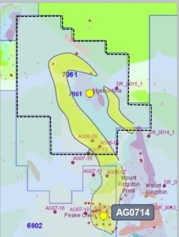
Multiple uranium occurrences within the project area. Drill hole AG0714 immediately south returned 2m @ 213ppm U + 329ppm V in pyritic and organic-rich Cadna-Owie Formation sediments. Up to 3,320ppm U recorded in granites to the south — Rössing-style intrusive-hosted mineralisation (Rössing Mine: 80Mt @ 0.035% U₃O₈).
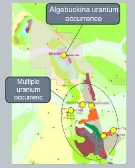
Regional Occurrence Map

Algebuckina uranium project regional map — uranium occurrences, drill hole positions, and project boundary, South Australia

Regional occurrence map showing uranium occurrences, drill hole positions, and the granted EL project boundary.

Key Facts

Tenure1 EL granted · 273 sqkm · South Australia
Known UraniumMultiple occurrences within EL; drill hole AG0714 (immediately south): 2m @ 213ppm U + 329ppm V + Cu + Ni
Host RockPyritic and organic-rich Cretaceous Cadna-Owie Formation sediments
Deposit StyleUnconformity-related · Roll-front / tabular uranium
Deposit AnaloguesAthabasca Basin (Canada) · Westmoreland (NT) · Bigrlyi (NT)
273 sqkmMultiple U OccurrencesGranted EL

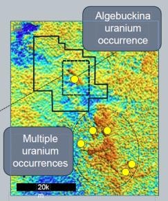
Project-Scale SARIG Map — U²/Th Signature

Algebuckina project-scale SARIG map — U²/Th radiometric signature over 30km strike, Cretaceous Cadna-Owie Formation, drill hole AG0714

Walk-up project-scale target — U²/Th radiometric signature over 30km strike, closely associated with the Cretaceous Cadna-Owie Formation. Drill hole AG0714 (immediately south of EL boundary): 2m @ 213ppm U + 329ppm V. Base image: SARIG — map.sarig.sa.gov.au

Key Facts

Anomaly Strike30km U²/Th radiometric signature along Cadna-Owie Formation contact
SignificanceWalk-up drill target — same stratigraphic unit as AG0714 intercept (2m @ 213ppm U)
Intrusive UUp to 3,320ppm U recorded in granites immediately south — Rössing-style mineralisation
Data SourceSARIG 2M scale geology, known uranium occurrences, regional geophysics
30km Strike AnomalyWalk-Up Drill TargetRössing-Style Mineralisation

Radiometric Signature Map — 7km Anomaly

Algebuckina radiometric signature map — well-defined 7km U²/Th anomaly coinciding with unconformity sequence and basal Algebuckina Sandstone

Well-defined 7km radiometric anomaly coinciding with the unconformity sequence of basement rocks and the basal Algebuckina Sandstone — a highly prospective structural setting for uranium concentration. Base image: SARIG — map.sarig.sa.gov.au

Key Facts

Anomaly Size7km × well-defined U²/Th radiometric anomaly
Structural SettingUnconformity between basement rocks and basal Algebuckina Sandstone — classic uranium trap geometry
SignificanceCoincidence of radiometric anomaly with unconformity contact defines a high-priority drill target
Data SourceSARIG regional geophysics — map.sarig.sa.gov.au
7km AnomalyUnconformity ContactHigh-Priority Drill Target

Northern Territory · 1 EL + 2 ELA · 324 sqkm

Yalyirimbi

Northern Territory · 1 EL + 2 ELA · 324 sqkm

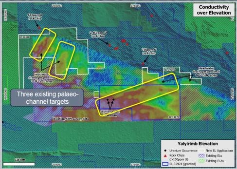
Three palaeo-channel targets identified within the project area. Existing drill holes within an incised Eocene-age palaeo-channel returned 4.5m @ 120ppm eU₃O₈, 1.5m @ 160ppm eU₃O₈, and 1.0m @ 110ppm eU₃O₈. Up to 0.17% U recorded in 'hot' basement rocks immediately north of the project — a potential uranium source feeding the palaeo-channel system. Additional REE (ionic-clay) potential identified.
AEM Conductivity Map — Three Palaeo-Channel Targets

Yalyirimbi uranium project AEM conductivity map — three palaeo-channel targets, uranium occurrences, rock chip samples, EL/ELA tenure, Northern Territory

AEM (airborne electromagnetic) conductivity draped over elevation — three palaeo-channel targets outlined in white, uranium occurrences, rock chip sample locations, and EL/ELA tenure boundaries shown.

Key Facts

Tenure1 EL granted + 2 ELA applications · 324 sqkm · Northern Territory
Survey MethodAEM (airborne electromagnetic) conductivity over elevation — defines palaeo-channel geometry at depth
Targets Identified3 palaeo-channel targets — tabular palaeo-channel and incised palaeo-channel REDOX deposit styles
Uranium SourceUp to 0.17% U in "hot" basement rocks immediately north — potential source for palaeo-channel mineralisation
REE PotentialPalaeo-channel ionic-clay REE potential identified — additional commodity upside
324 sqkm3 Palaeo-Channel TargetsAEM Survey CompletedREE Potential

Palaeo-Channel Detail Map — Drill-Confirmed Uranium

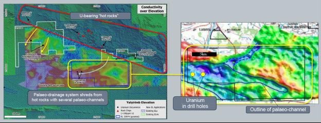
Yalyirimbi palaeo-channel detail map — uranium confirmed in drill holes, incised palaeo-channel outline, palaeo-drainage from hot rocks

Palaeo-channel detail showing uranium confirmed in drill holes within the outlined incised Eocene palaeo-channel. Palaeo-drainage system shreds from U-bearing 'hot rocks' to the north, with several palaeo-channels identified. Targets: tabular palaeo-channel and incised palaeo-channel REDOX deposits.

Key Facts

Best Intercepts4.5m @ 120ppm eU₃O₈ · 1.5m @ 160ppm eU₃O₈ · 1.0m @ 110ppm eU₃O₈ (existing drill holes)
Channel AgeIncised Eocene-age palaeo-channel — same age and style as Four Mile, Beverley, and Honeymoon deposits
Deposit StyleTabular palaeo-channel and incised palaeo-channel REDOX uranium deposits
Deposit AnaloguesFour Mile · Beverley · Honeymoon (Frome Embayment) · Mulga Rock (Eucla Basin)
Next StepsFollow-up drilling to test strike extensions and depth continuity of palaeo-channel mineralisation
Drill-Confirmed UraniumIncised Eocene Channel4.5m @ 120ppm eU₃O₈ISR-Amenable Style